User Guide: Difference between revisions
Fanomoswiki (talk | contribs) |
|||
| (31 intermediate revisions by 4 users not shown) | |||
| Line 20: | Line 20: | ||
== What you see (Screen Layout) == | == What you see (Screen Layout) == | ||
[[Image:FANOMOSmainscreen.PNG | | [[Image:FANOMOSmainscreen.PNG | 800px| The FANOMOS main GUI]] | ||
=Application and Login info= | =Application and Login info= | ||
| Line 66: | Line 66: | ||
====Altitude band edit==== | ====Altitude band edit==== | ||
===Compass=== | ===Compass=== | ||
==Map layer control== | |||
===Ordering of map layers=== | |||
===Enable txt=== | |||
===Transparent=== | |||
===Alpha slider=== | |||
===Gray=== | |||
===Map Selection=== | |||
===Profile Window | ===Menu options=== | ||
The left list has a popup menu. | |||
====Create spatial object==== | |||
When selecting this menu item, a spatial object is created from the selected items. | |||
==Profile Window== | |||
==Query Flight Panel== | ==Query Flight Panel== | ||
===Basic selection criteria area=== | ===Basic selection criteria area=== | ||
====Airport.help.query==== | |||
Airport query entry | |||
====FlightIdent==== | |||
Flight database ID, this ID is only unique within the dataset. | |||
===Advanced parameter criteria area=== | ===Advanced parameter criteria area=== | ||
==Flight Selection Panel== | |||
[[Image:FlightSelection1.png |top|700px]] | |||
===Table columns=== | |||
====Table column sorting==== | |||
[[Image:FlightColumnSort.png|top|100px]] | |||
Most column have sorting capabilities, by pressing on the table header the sorting can be enable/disabled and changed by order. Most columns have a sorting by letters and numerical combined, which mean that eg. A300 is after A75. | |||
===Print flight selection=== | |||
Create a PDF containing the flights (or selected flights when in multi select) or when in single flight the details of the selected flight | |||
==Flight | ===Flight selection=== | ||
=== | [[Image:FlightSel.png |top|400px]] | ||
===Track coloring=== | |||
===Altitude values=== | ===Altitude values=== | ||
===Deselect flight selection=== | ===Deselect flight selection=== | ||
| Line 110: | Line 143: | ||
==Preferences Panel== | ==Preferences Panel== | ||
===GUI coordinate system=== | ===GUI coordinate system=== | ||
[[Image:Fanomos7.png |left|32px]] | |||
Fanomos uses a fixed internal coordinate system used for all calculations. This cannot | Fanomos uses a fixed internal coordinate system used for all calculations. This cannot be changed by the user and depends on the initial installation. Besides this the user can choose in which coordinate system the GUI will represent the data. | ||
Some coordinate system also have a several representation forms within the chosen coordinate system. The preview label will show the current selected system. | Some coordinate system also have a several representation forms within the chosen coordinate system. The preview label will show the current selected system. | ||
[[Image:GUICoordinateSystem.png |top|300px]] | |||
Currently following systems are available; | Currently following systems are available; | ||
* RD - Rijksdriehoek system https://nl.wikipedia.org/wiki/Rijksdriehoeksco%C3%B6rdinaten | * RD - Rijksdriehoek system https://nl.wikipedia.org/wiki/Rijksdriehoeksco%C3%B6rdinaten | ||
| Line 122: | Line 159: | ||
* EPSG 3857 - Web Mercator system https://en.wikipedia.org/wiki/Web_Mercator_projection | * EPSG 3857 - Web Mercator system https://en.wikipedia.org/wiki/Web_Mercator_projection | ||
* ECEF - Earth-centered, Earth-fixed system https://en.wikipedia.org/wiki/Earth-centered,_Earth-fixed_coordinate_system | * ECEF - Earth-centered, Earth-fixed system https://en.wikipedia.org/wiki/Earth-centered,_Earth-fixed_coordinate_system | ||
==Search Location Panel== | |||
===Location search=== | |||
Hiermee worden de zoektermen opgegeven. De Solr-syntax voor zoektermen kan hier worden toegepast, bijv. combineren met "and", en het gebruik van dubbele quotes voor opeenvolgende zoektermen. Zoektermen mogen incompleet zijn. Ook wordt er gebruik gemaakt van synoniemen. | |||
Voorbeelden: Utrecht: geeft resultaten terug met de zoekterm Utrecht, bijv. adressen in de stad Utrecht, woonplaatsen en gemeenten in de provincie Utrecht. | |||
"De Bilt": geeft resultaten terug met de zoekterm De Bilt, bijv. de woonplaats en gemeente De Bilt, of adressen in deze woonplaats. | |||
"Sint Jacob" Utre: geeft o.a. adressen terug waarvan er delen achtereenvolgens beginnen met "Sint" en "Jacob", of met "St" (synoniem) en "Jacob", en waar ook een deel met "Utre" begint. Een voorbeeld is het adres St.-Jacobsstraat 200 (officiële schrijfwijze) in Utrecht. | |||
== Keyboard shortcuts == | |||
* '''Key 'A'''' = move map left | |||
* '''Key 'D'''' = move map right | |||
* '''Key 'W'''' = move map up | |||
* '''Key 'S'''' = move map down | |||
* '''Key 'F'''' = Same as mouse click left | |||
=Calculations= | =Calculations= | ||
Latest revision as of 07:45, 24 October 2024
FANOMOS[edit]
In FANOMOS, data collected for flight data monitoring serve as a solid basis to analyse the impact of flight operations in environmental impact studies, for instance. These studies can be conducted for real-time as well as for historic data. For future scenarios, for which monitored data are not available, simulated flight data can be fed into the monitoring system to compare historic and future situations.
Flight tracks stored in FANOMOS can be accessed via:
- A web service access (REST API) for coupling flight data with your own information systems
- Graphical user interface
FANOMOS provides detailed in-depth insight to flight tracks to facilitate several goals:
- Impact studies such as environmental metrics
- Safety studies
- Flight Performance studies and trend analysis
- Facilitate information sharing
- Improvement of model input data
Interface Overview[edit]
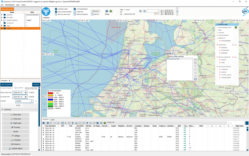
What you see (Screen Layout)[edit]
Application and Login info[edit]
The window title holds the application and login information.
Modify User Information[edit]
To edit the user data, select the menu option Modify User Information. In this window the user can edit personal information. Please note that this option is not available for Guest users.
Basic Operations[edit]
Menu[edit]
The file menu contains the Open menu folder, this contains all the dataset which are available to the user. For the normal user there is only one dataset available, but the system users will have more options. When a different dataset is choose the application is switched to that new dataset, please note that the map viewpoint isn't changed.
The last option is the Quit option.
Viewer Toolbar[edit]
Map Windows[edit]
Printing[edit]
QuickInfo[edit]
Zoom[edit]
Map Panel[edit]
Map Area[edit]
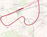
Track intersections window[edit]
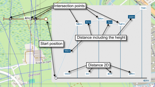
The track intersections window show the distances between the track points. This window can be shown in following way;
- First draw a intersection line by press and hold the CTRL key and draw the line while pressing the right (menu) button.
Intersection points will be show with squares, a total distance will also be shown.
- Click with the left mouse button on the distance label and the window will be shown.
Only one window will shown at the same time. This window can be move by pressing the left mouse button and dragging this window.
Control Area[edit]
Altitude Bands[edit]
Altitude band edit[edit]
Compass[edit]
Map layer control[edit]
Ordering of map layers[edit]
Enable txt[edit]
Transparent[edit]
Alpha slider[edit]
Gray[edit]
Map Selection[edit]
Menu options[edit]
The left list has a popup menu.
Create spatial object[edit]
When selecting this menu item, a spatial object is created from the selected items.
Profile Window[edit]
Query Flight Panel[edit]
Basic selection criteria area[edit]
Airport.help.query[edit]
Airport query entry
FlightIdent[edit]
Flight database ID, this ID is only unique within the dataset.
Advanced parameter criteria area[edit]
Flight Selection Panel[edit]
Table columns[edit]
Table column sorting[edit]
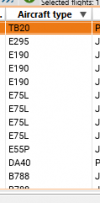
Most column have sorting capabilities, by pressing on the table header the sorting can be enable/disabled and changed by order. Most columns have a sorting by letters and numerical combined, which mean that eg. A300 is after A75.
Print flight selection[edit]
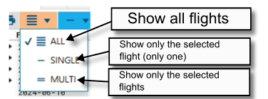
Create a PDF containing the flights (or selected flights when in multi select) or when in single flight the details of the selected flight
Flight selection[edit]
Track coloring[edit]
Altitude values[edit]
Deselect flight selection[edit]
Flight statistics[edit]
Flight plan and track export[edit]
Remove flights from the result set[edit]
Use selected flight as result set[edit]
Track density[edit]
Flight adapt functionality (for preserved users only)[edit]
Property Panels[edit]
Aircraft Property Panel[edit]
Airport Property Panel[edit]
Builtup Area Property Panel[edit]
Edit Builtup Area Points[edit]
Flight Property Panel[edit]
Radar Property Panel[edit]
Route Property Panel[edit]
Route Base Property Panel[edit]
Route Segment Property Panel[edit]
Runway Property Panel[edit]
Preferences Panel[edit]
GUI coordinate system[edit]
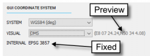
Fanomos uses a fixed internal coordinate system used for all calculations. This cannot be changed by the user and depends on the initial installation. Besides this the user can choose in which coordinate system the GUI will represent the data. Some coordinate system also have a several representation forms within the chosen coordinate system. The preview label will show the current selected system.
Currently following systems are available;
- RD - Rijksdriehoek system https://nl.wikipedia.org/wiki/Rijksdriehoeksco%C3%B6rdinaten
- UTM (DFS) - UTM system, DFS https://en.wikipedia.org/wiki/Universal_Transverse_Mercator_coordinate_system
- UTM - not fully operational
- WGS84 (deg) - Lat/Lon system https://en.wikipedia.org/wiki/World_Geodetic_System#WGS84
- EPSG 3857 - Web Mercator system https://en.wikipedia.org/wiki/Web_Mercator_projection
- ECEF - Earth-centered, Earth-fixed system https://en.wikipedia.org/wiki/Earth-centered,_Earth-fixed_coordinate_system
Search Location Panel[edit]
Location search[edit]
Hiermee worden de zoektermen opgegeven. De Solr-syntax voor zoektermen kan hier worden toegepast, bijv. combineren met "and", en het gebruik van dubbele quotes voor opeenvolgende zoektermen. Zoektermen mogen incompleet zijn. Ook wordt er gebruik gemaakt van synoniemen.
Voorbeelden: Utrecht: geeft resultaten terug met de zoekterm Utrecht, bijv. adressen in de stad Utrecht, woonplaatsen en gemeenten in de provincie Utrecht.
"De Bilt": geeft resultaten terug met de zoekterm De Bilt, bijv. de woonplaats en gemeente De Bilt, of adressen in deze woonplaats.
"Sint Jacob" Utre: geeft o.a. adressen terug waarvan er delen achtereenvolgens beginnen met "Sint" en "Jacob", of met "St" (synoniem) en "Jacob", en waar ook een deel met "Utre" begint. Een voorbeeld is het adres St.-Jacobsstraat 200 (officiële schrijfwijze) in Utrecht.
Keyboard shortcuts[edit]
- Key 'A' = move map left
- Key 'D' = move map right
- Key 'W' = move map up
- Key 'S' = move map down
- Key 'F' = Same as mouse click left
